About Light Pollution Map
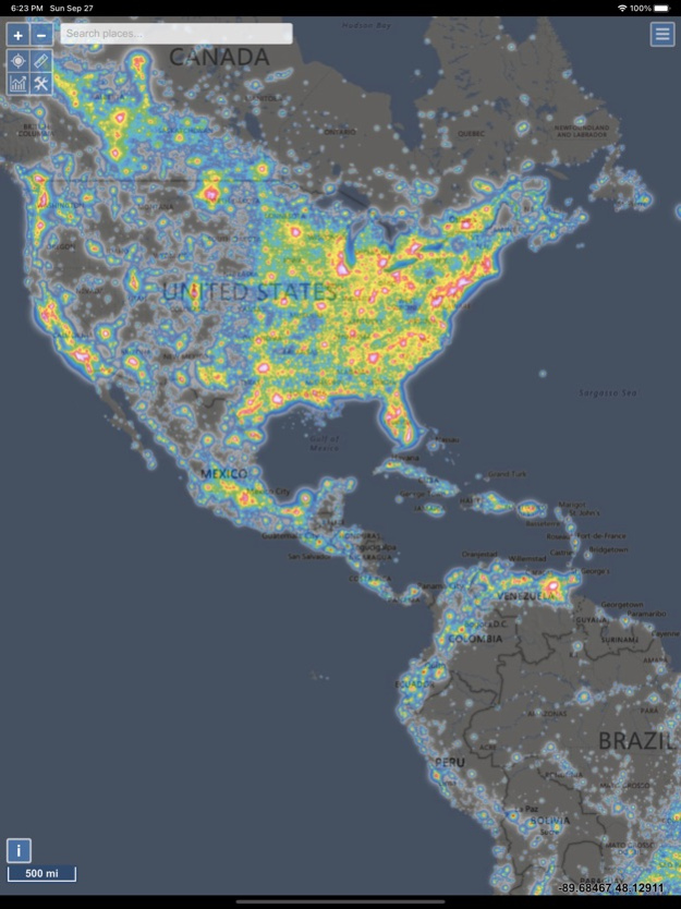
The map displays VIIRS/World Atlas/Clouds/Aurora/IAU observatories and the user SQM measurements overlay over Microsoft Bing base layers (road and hybrid Bing maps). The primary use is to show VIIRS/DMSP data in a...
The map displays VIIRS/World Atlas/Clouds/Aurora/IAU observatories and the user SQM measurements overlay over Microsoft Bing base layers (road and hybrid Bing maps).
The primary use is to show VIIRS/DMSP data in a friendly manner, but over time it also included some other interesting overlays that concern light pollution like SQM/SQC, World Atlas 2015 zenith brightness, clouds, aurora and IAU observatories. If you have a permanent SQM reader installed you can add it to the map by sending me an e-mail.
If you want an analysis of radiance (VIIRS/DMSP) changes over a period of time, then please use the Lighttrends application (look under Help).
Please send comments and requests for new features via email (look under help)
Functionalities:
- VIIRS, Sky Brightness (World Atlas 2015), Cloud coverage and Aurora forecast layers
- VIIRS and Sky Brightness layers can be displayed in color blind friendly colors
- Road & Satellite base maps
- Cloud animation for the last 12 hours
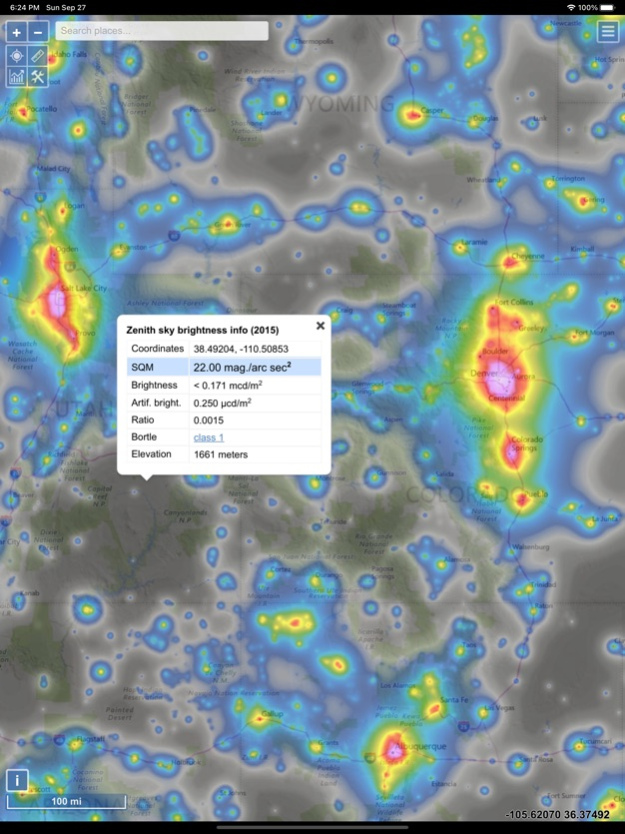
- Get detail radiance and SQM values from layers at a click. For World Atlas 2015, you also get Bortle class estimation.
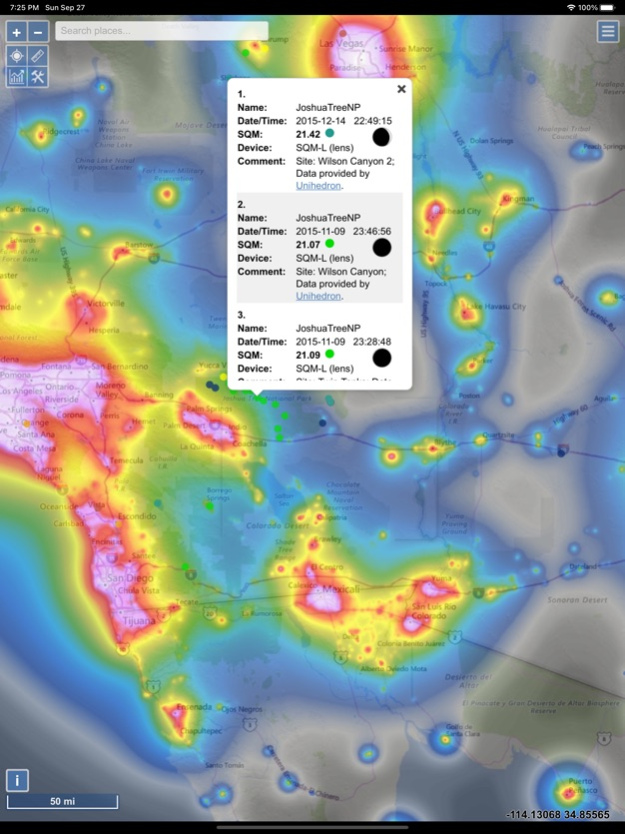
- SQM, SQM-L, SQC, SQM-LE, SQM readings submitted by users
- Submit your own SQM (L) readings
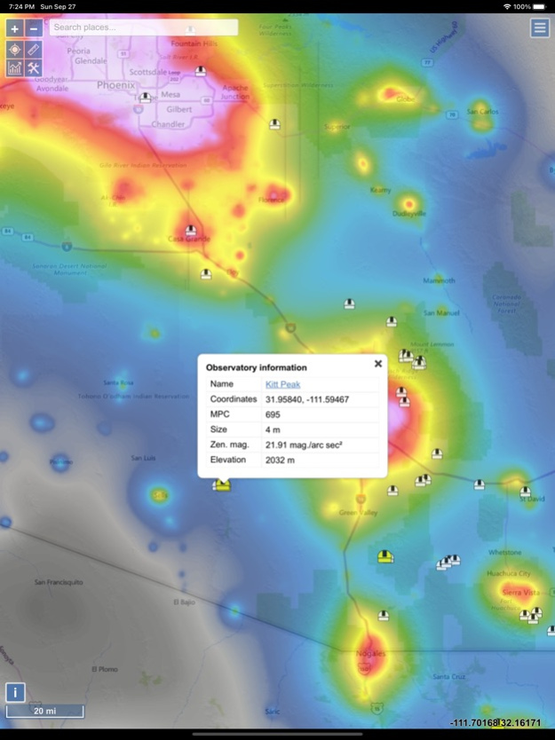
- Observatories layer
- Save your favorite locations
- Distance measurement tool with azimuth angle report
- Offline mode (Sky brightness map and a base map are saved to your device, so it will be displayed when you are offline)
Aug 18, 2023
Version 1.1.21
- VIIRS chart now has an option to display monthly values
- Fixed trailing artefact produced by the popup window on some devices
- Fixed the issue of previously downloaded offline maps not showing after app update
- Fixed the issue of search bar not showing when there are too many users on the server
Previous Versions
Here you can find the changelog of Light Pollution Map since it was posted on our website on 2020-09-30 12:05:16.
The latest version is 1.1.21 and it was updated on 2024-04-19 20:25:57. See below the changes in each version.
Light Pollution Map version 1.1.21
Updated At: 2023-08-18
Changes: Aug 18, 2023
Version 1.1.21
- VIIRS chart now has an option to display monthly values
- Fixed trailing artefact produced by the popup window on some devices
- Fixed the issue of previously downloaded offline maps not showing after app update
- Fixed the issue of search bar not showing when there are too many users on the server
Light Pollution Map version 1.1.18
Updated At: 2023-05-29
Changes: May 29, 2023
Version 1.1.18
- VIIRS 2022 added
- Search for places now first searches through Geonames database and if it fails it will search Bing's database
- Other minor fixes
Light Pollution Map version 1.1.17
Updated At: 2022-08-11
Changes: Aug 11, 2022 Version 1.1.17
- Added exponential trend (annual % change) to VIIRS radiance chart
- Fixed the issue of non working offline mode in the last version (re-download the cache if not working)
Light Pollution Map version 1.1.16
Updated At: 2022-04-15
Changes: Apr 15, 2022 Version 1.1.16
- VIIRS data source is now NASA instead of NOAA
- Fixed the issue with adding a marker to "My locations"
Light Pollution Map version 1.1.13
Updated At: 2021-10-24
Changes: Oct 24, 2021 Version 1.1.13
- VIIRS 2021 overlay added
Light Pollution Map version 1.1.10
Updated At: 2021-05-10
Changes: May 10, 2021 Version 1.1.10
- New option under settings to display VIIRS/World Atlas overlays in a color blind friendly style
- Enabled landscape mode for iPad
- Fixed a bug from previous release where basemap was not displayed in offline mode
- Other
Light Pollution Map version 1.1.9
Updated At: 2021-01-20
Changes: Jan 20, 2021 Version 1.1.9
- New VIIRS overlay (2020)
- Search is now using Geonames database instead of Microsoft service
Light Pollution Map version 1.1.8
Updated At: 2020-12-29
Changes: Dec 29, 2020 Version 1.1.8
- Minor bug fixes
Light Pollution Map version 1.1.7
Updated At: 2020-12-15
Changes: Dec 15, 2020 Version 1.1.7
- Added high DPI base map option under settings, which should provide larger map labels (especially if you zoom in)
Light Pollution Map version 1.1.6
Updated At: 2020-11-10
Changes: Nov 10, 2020 Version 1.1.6
- Map navigation and help menu fix for iOS 12.x
- Other minor cosmetic changes
Disclaimer
Official App Store Link
We do not host Light Pollution Map on our servers. We did not scan it for viruses, adware, spyware or other type of malware. This app is hosted by Apple and passed their terms and conditions to be listed there. We recommend caution when installing it.
The App Store link for Light Pollution Map is provided to you by apps112.com without any warranties, representations or guarantees of any kind, so access it at your own risk.
If you have questions regarding this particular app contact the publisher directly. For questions about the functionalities of apps112.com contact us.